External links
Maps
Beach locations are defined by km-pole numbers, indicated on wooden poles every 250 m. See map (zip-file) with beach from Den Helder to Hoek van Holland, showing these numbers and also
public transport info.
Satellite images and aerial photograps
Google Maps [6] has aerial photographs of the entire country, combined with a full map with town and street names. This is also available through Google Earth.
Miscellaneous
Footnotes and References
↑ [3][4]:
2006bevolkingskerneninnederlandart.pdf (pdf, in Dutch) on: [7], look for stedelijke agglomeraties
2005grootstedelijkeagglomeratiesstadsgewestenafgebakendart.pdf (pdf, in Dutch)
from: [cbs.nl/nl-NL/menu/themas/dossiers/nederland-regionaal/publicaties/artikelen/archief/2005/2005-grootstedelijke-agglomeraties-en-stadsgewesten-afgebakend-art.htm] on: [8]
2004k4v4p037art.pdf (pdf, in Dutch) on: [9]; look for stedelijke agglomeraties
- Netherlands Geography
- Map showing first two digits of postal codes (see List of postal codes in the Netherlands), ditto
- Map showing first three digits of postal codes for the midwest of the Netherlands
- Locate town or village; find municipality it is part of, range of postal codes, and some other basic data
- Find postal code for a full address, and address for full postal code plus street number
- For each municipality a pdf file - with statistics in Dutch, and with (towards the end) a map showing the neighborhoods (together ca. 11,000), and listing (a few pages further) the population
figures etc. as well as the grouping into quarters (together ca 2,400) - Lists of "places" (towns, villages, and various smaller entities), with municipality: alphabetical (ca. 4,800) - by province (extended, ca. 7,000)
Maps
- Routenet.nl Most used website for maps and directions in the Netherlands, also gives address range for a full postal code, and shows the four-digit parts of the postal codes on the maps.
Published by Locatienet BV - Multimap - shows geographic coordinates and allows a direct link to a map for a given location and with a given zoom level; shows all railways from scale 1:500k, all railway stations from 1:50k
- Vialys
- http://www.map24.nl/index.php?language=en (also used by http://www.lycos.nl/lycos/route/ )
- http://www.welkeafslag.nl (Online website which can calcalute the directions to travel between two addresses)
- http://www.routemaster.nl/ ; similar or the same:
- http://route.anwb.nl/zoek_plattegrond.html
- http://www.andes.nl/ (select "Interactieve kaart"): the same but one has to know the postal code
- http://www.travelmanager.nl/nl/contentimap/index.html: ditto
- maps of public transport planner http://www.9292ov.nl
- to link directly to a city: http://www.mapquest.com/maps/map.adp?country=NL&city=, type city at the end of the URL
- to link directly to a postal code: http://www.mapquest.com/maps/map.adp?country=NL&zipcode=, type four-digit code at the end of the URL
- to link to given geographic coordinates: latlongtype=decimal&latitude=...&longitude=... - a red star shows the location on the map; in the largest scale one pixel is ca. 1.5 m or from
0.000015 degrees; therefore for the number of degrees up to five decimals can make sense for exact pinpointing (although the star size is 16x16 pixels and not transparent, hence a
small map detail and ca. one letter of text may be covered by the star) - specify zoom level 0-9: add "&zoom=zoom level" (note that the zoom level in MapQuest's hoverbox have numbers which are one more, the range is 1-10)
- http://de.maps.yahoo.com/py/maps.py?country=nl
- Michelin
- NS rail travel planner - contains a detailed map of the whole country; to view a location, specify it as destination and choose an arbitrary point of departure, then ask for the route map of the post
transport from the train station. Of course the map shows railroads and train stations clearly. If you specify "Public transport" as means of pre or post transport, you will be redirected to http:
//www.9292ov.nl (see above). - Yellow pages / Telephone directory - A map (plattegrond) is provided after searching for a company or person; if one just wants to use the map, do an arbitrary search like [4], select Plattegrond
and by zooming out and selecting an area to zoom in go to any part of the map. - Topographical Service map selection tool (can to some extent be used as a map by itself)
- Single png-map (zip)
- See also the links of:
- http://www.landkaartenindex.nl/nederland/nederland.htm ; includes [5], a list of links to towns maps
- Detailed town maps of Rijnland/Citoplan (note that on the overview maps, for enlargement one can often either select a box or a town and then a box)
- Detailed town maps of Falkplan (see at the bottom of that webpage)
Beach locations are defined by km-pole numbers, indicated on wooden poles every 250 m. See map (zip-file) with beach from Den Helder to Hoek van Holland, showing these numbers and also
public transport info.
Satellite images and aerial photograps
Google Maps [6] has aerial photographs of the entire country, combined with a full map with town and street names. This is also available through Google Earth.
Miscellaneous
Footnotes and References
↑ [3][4]:
2006bevolkingskerneninnederlandart.pdf (pdf, in Dutch) on: [7], look for stedelijke agglomeraties
2005grootstedelijkeagglomeratiesstadsgewestenafgebakendart.pdf (pdf, in Dutch)
from: [cbs.nl/nl-NL/menu/themas/dossiers/nederland-regionaal/publicaties/artikelen/archief/2005/2005-grootstedelijke-agglomeraties-en-stadsgewesten-afgebakend-art.htm] on: [8]
2004k4v4p037art.pdf (pdf, in Dutch) on: [9]; look for stedelijke agglomeraties


| AAAPOE Campus |


| AAAPOE Campus: 001: Geography Hall 地理館 地理馆 001-006: Geography of the Netherlands from Wikipedia, the free encyclopedia |
| |
| |
| |
| |
| |
| |
| |
| |
| |
| |
| |
| |
| |
| |
| |
| |
| |
| |
| |
| |
| |
| |
| |


The geography of the Netherlands is unusual in that much of its land has been reclaimed from the sea and is
below sea level, protected by dikes. Another factor that has influenced its physical appearance is that the country
is among the most densely populated on earth. It is ranked 15th overall on that scale, but is behind only three
countries having a population over 10 million. Unsurprisingly, the Netherlands is highly urbanised.
Landscape
The country can be divided into 2 areas:
the low and flat lands in the west and north. These lands, including the reclaimed polders and river deltas, make
up about half of its surface area and are less than 1 metre (3.3 ft) above sea level, much of it actually below sea
level. An extensive range of seawalls and coastal dunes protect the Netherlands from the sea, and levees and
dikes along the rivers protect against river flooding.
the higher lands with minor hills in the east and south. Even this portion is mostly flat; only in the extreme south of
the country does the land rise to any significant extent, in the foothills of the Ardennes mountains. This is where
Vaalserberg is located, the country's highest point at 322.7 metres (1,053 ft) above sea level.
Statistics
Geographic coordinates: ca. 51° - 53° N, 4° - 7° E
The Dutch RD coordinate system (Rijksdriehoeksmeting) is also in common use; see [1] (pdf, in Dutch; see little
map on p.1) and converter. There is a west-east coordinate between 0 and 280 km, and a south-north coordinate
between 300 and 620 km.
The reference point is the Onze-Lieve-Vrouwentoren (Our Lady's Tower) in Amersfoort, with RD coordinates
(155.000, 463.000) and geographic coordinates approximately 52°9′N, 5°23′E.
Rate of change of solar time: 1 minute per 17 km EW.
Highest altitude of the Sun varies at the center from 38.5 - 23.5 = 15 degrees in December to 38.5 + 23.5 = 62
degrees in June. This occurs, depending on east-west location, at ca. 11:40 UTC, i.e. local time 12:40 in winter
and 13:40 in summer.
below sea level, protected by dikes. Another factor that has influenced its physical appearance is that the country
is among the most densely populated on earth. It is ranked 15th overall on that scale, but is behind only three
countries having a population over 10 million. Unsurprisingly, the Netherlands is highly urbanised.
Landscape
The country can be divided into 2 areas:
the low and flat lands in the west and north. These lands, including the reclaimed polders and river deltas, make
up about half of its surface area and are less than 1 metre (3.3 ft) above sea level, much of it actually below sea
level. An extensive range of seawalls and coastal dunes protect the Netherlands from the sea, and levees and
dikes along the rivers protect against river flooding.
the higher lands with minor hills in the east and south. Even this portion is mostly flat; only in the extreme south of
the country does the land rise to any significant extent, in the foothills of the Ardennes mountains. This is where
Vaalserberg is located, the country's highest point at 322.7 metres (1,053 ft) above sea level.
Statistics
Geographic coordinates: ca. 51° - 53° N, 4° - 7° E
- 1 degree = 111 km NS, 68 km EW (the ratio is 0.61, the cosine of the latitude)
- 1 minute = 1,850 m NS (ca. 1 nautical mile), 1,140 m EW
- 1 second = 31 m NS, 19 m EW
The Dutch RD coordinate system (Rijksdriehoeksmeting) is also in common use; see [1] (pdf, in Dutch; see little
map on p.1) and converter. There is a west-east coordinate between 0 and 280 km, and a south-north coordinate
between 300 and 620 km.
The reference point is the Onze-Lieve-Vrouwentoren (Our Lady's Tower) in Amersfoort, with RD coordinates
(155.000, 463.000) and geographic coordinates approximately 52°9′N, 5°23′E.
Rate of change of solar time: 1 minute per 17 km EW.
Highest altitude of the Sun varies at the center from 38.5 - 23.5 = 15 degrees in December to 38.5 + 23.5 = 62
degrees in June. This occurs, depending on east-west location, at ca. 11:40 UTC, i.e. local time 12:40 in winter
and 13:40 in summer.
Map references: Europe
Area:
total: 41,526 km² (16,033
mile²)
land: 33,883 km² (13,082
mile²)
water: 7,643 km² (2951
mile²)
Land boundaries:
total: 1,027 km (638
miles)
border countries:
miles)
Maritime claims:
exclusive fishing zone:
200 nautical miles (370
km / 230 miles)
territorial sea: 12
nautical miles (22 km /
14 miles)
Climate: temperate;
marine; cool summers
and mild winters
Terrain: mostly coastal
lowland and reclaimed
land (polders); some
hills in southeast
Elevation extremes:
lowest point:
Zuidplaspolder
(Nieuwerkerk aan den
IJssel) 7 m (23 ft) below
sea level.
highest point:
Vaalserberg 322.7 m
(1053 ft) above sea level.
Natural resources:
natural gas, petroleum,
arable land
Land use: (1996 est.)
arable land: 25%
permanent crops: 3%
permanent pastures:
25%
forests and woodland:
8%
other: 39%
Irrigated land (1996 est.):
6,000 km² (2300 miles²)
Natural hazards: flooding
by sea and rivers is a
constant danger. The
extensive system of
dikes, dams, and sand
dunes protect nearly one-
half of the total area from
being flooded during the
heavy autumn storms
from the north-west.
Environment - current
issues: water pollution in
the form of heavy metals,
organic compounds, and
fetilisers such as
nitrates and phosphates;
air pollution from
vehicles and refining
activities; acid rain
Area:
total: 41,526 km² (16,033
mile²)
land: 33,883 km² (13,082
mile²)
water: 7,643 km² (2951
mile²)
Land boundaries:
total: 1,027 km (638
miles)
border countries:
- Belgium 450 km
(280 miles) - Germany 577 km
(359 miles)
miles)
Maritime claims:
exclusive fishing zone:
200 nautical miles (370
km / 230 miles)
territorial sea: 12
nautical miles (22 km /
14 miles)
Climate: temperate;
marine; cool summers
and mild winters
Terrain: mostly coastal
lowland and reclaimed
land (polders); some
hills in southeast
Elevation extremes:
lowest point:
Zuidplaspolder
(Nieuwerkerk aan den
IJssel) 7 m (23 ft) below
sea level.
highest point:
Vaalserberg 322.7 m
(1053 ft) above sea level.
Natural resources:
natural gas, petroleum,
arable land
Land use: (1996 est.)
arable land: 25%
permanent crops: 3%
permanent pastures:
25%
forests and woodland:
8%
other: 39%
Irrigated land (1996 est.):
6,000 km² (2300 miles²)
Natural hazards: flooding
by sea and rivers is a
constant danger. The
extensive system of
dikes, dams, and sand
dunes protect nearly one-
half of the total area from
being flooded during the
heavy autumn storms
from the north-west.
Environment - current
issues: water pollution in
the form of heavy metals,
organic compounds, and
fetilisers such as
nitrates and phosphates;
air pollution from
vehicles and refining
activities; acid rain

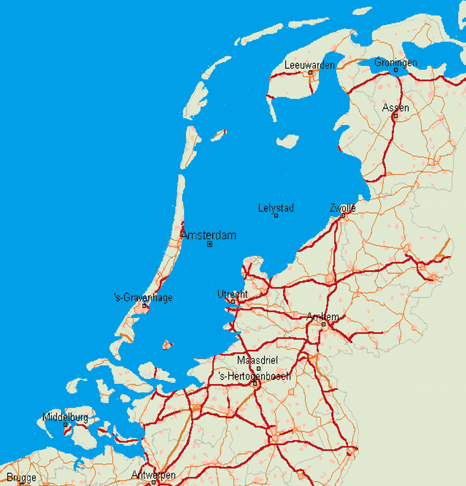
| Map of the Netherlands |
| The Netherlands without dikes, or: above sea level |
Environment - international agreements:
party to: Air Pollution, Air Pollution-Nitrogen Oxides, Air
Pollution-Sulphur 85, Air Pollution-Sulphur 94, Air
Pollution-Volatile Organic Compounds,
Antarctic-Environmental Protocol, Antarctic Treaty,
Biodiversity, Climate Change, Desertification,
Endangered Species, Environmental Modification,
Hazardous Wastes, Law of the Sea, Marine Dumping,
Marine Life Conservation, Nuclear Test Ban, Ozone
Layer Protection, Ship Pollution, Tropical Timber 83,
Tropical Timber 94, Wetlands, Whaling
signed, but not ratified: Air Pollution-Persistent Organic
Pollutants, Biodiversity, Climate Change-Kyoto Protocol
Geography - note: located at mouths of three major
European rivers (Rhine, Maas or Meuse, and Scheldt)
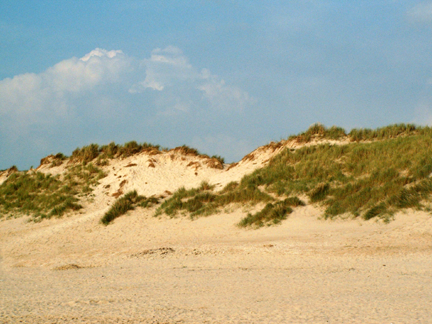
| The coastal dunes are vital to the existence of the Netherlands. |
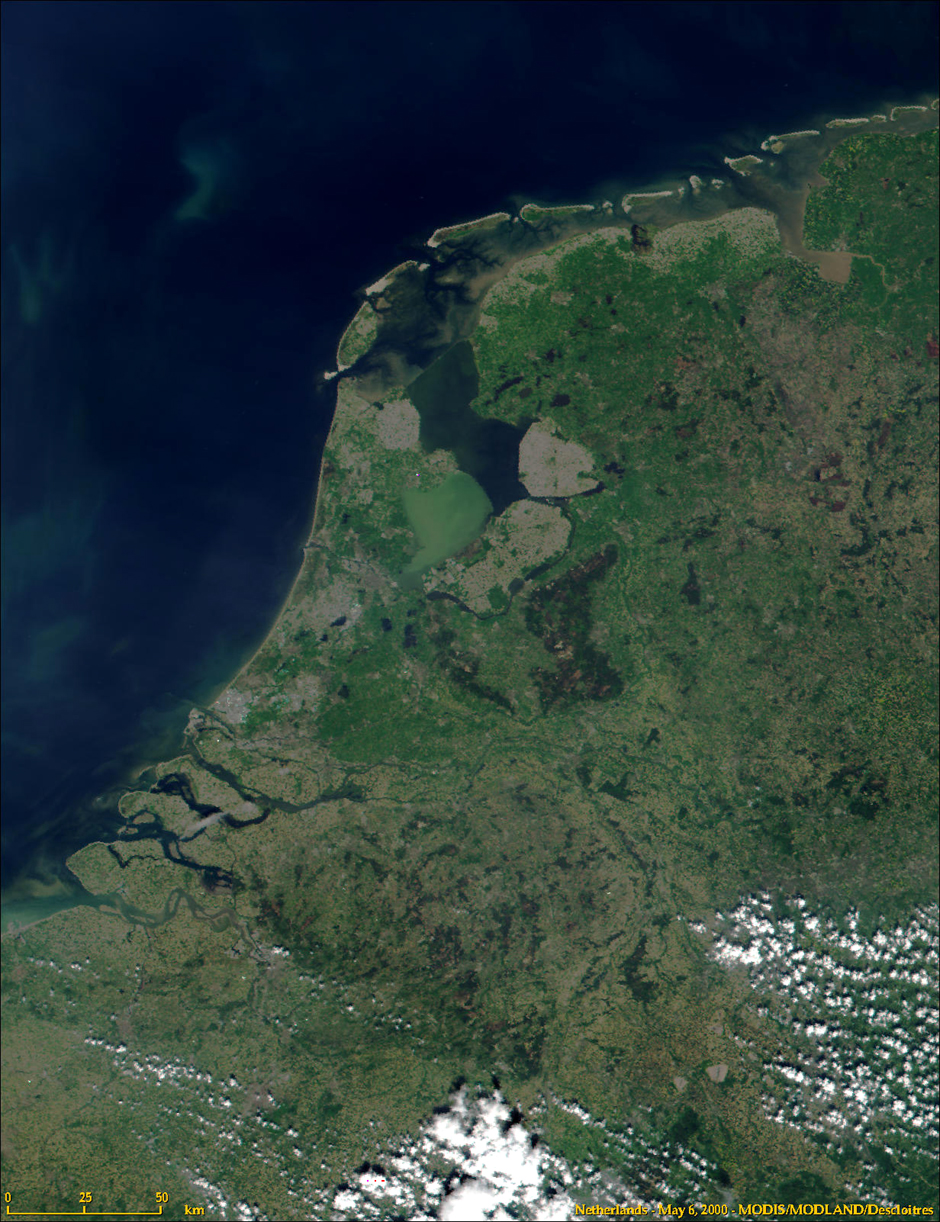
| Satellite overview of the Netherlands |
Urbanisation
Largest cities
Sources are CBS based
see [2]; and [1]
with their provinces in 2006:
1 Amsterdam (North Holland) 744,740 inhabitants
2 Rotterdam (South Holland) 581,615 inh.
3 The Hague ('s-Gravenhage) (South Holland) 474,245 inh.
4 Utrecht (Utrecht) 290,529 inh.
5 Eindhoven (North Brabant) 209,601 inh.
6 Tilburg (North Brabant) 200,975 inh.
7 Almere (Flevoland) 181,990 inh.
8 Groningen (Groningen) 180,824 inh.
9 Breda (North Brabant) 170,451 inh.
10 Nijmegen (Gelderland) 160,732 inh.
11 Apeldoorn (Gelderland) 155,328 inh.
12 Enschede (Overijssel) 154,311 inh.
13 Haarlem (North Holland) 147,179 inh.
14 Arnhem (Gelderland) 142,638 inh.
15 Zaanstad (North Holland) 141,829 inh.
16 Amersfoort (Utrecht) 139,914 inh.
17 Haarlemmermeer (capital city: Hoofddorp) (North Holland) 139,396 inh.
18 's-Hertogenbosch (North Brabant) 135,787 inh.
19 Zoetermeer (South Holland) 118,534 inh.
20 Dordrecht (South Holland) 118,443 inh.
21 Maastricht (Limburg) 118,378 inh.
22 Leiden (South Holland) 117,363 inh.
23 Zwolle (Overijssel) 115,144 inh.
24 Emmen (Drenthe) 108,929 inh.
25 Ede (Gelderland) 107,528 inh.
26 Westland (capital city: Naaldwijk) (South Holland) 99,067 inh.
27 Deventer (Overijssel) 96,958 inh.
28 Sittard-Geleen (capital city: Sittard) (Limburg) 96,024 inh.
29 Delft (South Holland) 95,237 inh.
30 Alkmaar (North Holland) 93,986 inh.
Largest agglomerations
Sources are CBS based
see [3] and [2]
- Amsterdam (Amsterdam, Amstelveen, Diemen, Landsmeer, Oostzaan, Wormerland, Zaanstad)
- Rotterdam (Rotterdam, Barendrecht, Capelle aan den IJssel, Krimpen aan den IJssel,
Spijkenisse, Schiedam, Vlaardingen, Maasland, Maassluis, Rozenburg)
- The Hague ('s-Gravenhage, Rijswijk, Wateringen, Voorburg, Leidschendam, Wassenaar)
- Utrecht (Utrecht, Nieuwegein, IJsselstein, Maarssen)
- Eindhoven (Eindhoven, Veldhoven, Geldrop, Son en Breugel, Waalre)
- Tilburg (Tilburg, Goirle)
- Haarlem (Haarlem, Heemstede, Bloemendaal)
- Groningen (Groningen, Haren)
- Arnhem (Arnhem, Rozendaal)
- Leiden (Leiden, Katwijk, Voorschoten, Leiderdorp, Oegstgeest, Rijnsburg, Valkenburg,
Warmond)
- Dordrecht (Dordrecht, 's-Gravendeel, Hardinxveld-Giessendam, Papendrecht, Sliedrecht,
Zwijndrecht)
- Heerlen (Heerlen, Kerkrade, Landgraaf, Brunssum)
- 's-Hertogenbosch ('s-Hertogenbosch, Vught)
- Sittard-Geleen (Sittard-Geleen, Beek, Stein)
- Amersfoort (Amersfoort, Leusden)
References
See also
Sources are CBS based
see [3] and [2]
- Amsterdam (Amsterdam, Amstelveen, Diemen, Landsmeer, Oostzaan, Wormerland, Zaanstad)
- Rotterdam (Rotterdam, Barendrecht, Capelle aan den IJssel, Krimpen aan den IJssel,
Spijkenisse, Schiedam, Vlaardingen, Maasland, Maassluis, Rozenburg)
- The Hague ('s-Gravenhage, Rijswijk, Wateringen, Voorburg, Leidschendam, Wassenaar)
- Utrecht (Utrecht, Nieuwegein, IJsselstein, Maarssen)
- Eindhoven (Eindhoven, Veldhoven, Geldrop, Son en Breugel, Waalre)
- Tilburg (Tilburg, Goirle)
- Haarlem (Haarlem, Heemstede, Bloemendaal)
- Groningen (Groningen, Haren)
- Arnhem (Arnhem, Rozendaal)
- Leiden (Leiden, Katwijk, Voorschoten, Leiderdorp, Oegstgeest, Rijnsburg, Valkenburg,
Warmond)
- Dordrecht (Dordrecht, 's-Gravendeel, Hardinxveld-Giessendam, Papendrecht, Sliedrecht,
Zwijndrecht)
- Heerlen (Heerlen, Kerkrade, Landgraaf, Brunssum)
- 's-Hertogenbosch ('s-Hertogenbosch, Vught)
- Sittard-Geleen (Sittard-Geleen, Beek, Stein)
- Amersfoort (Amersfoort, Leusden)
References
- ^ {{2006bevolkingskerneninnederlandart.pdf
- 2005grootstedelijkeagglomeratiesstadsgewestenafgebakendart.pdf
- 2004k4v4p037art.pdf}}
- ^ {{2006bevolkingskerneninnederlandart.pdf
- - 2005grootstedelijkeagglomeratiesstadsgewestenafgebakendart.pdf
- - 2004k4v4p037art.pdf}}
See also

| | | | | | |
